

According to reports, 300,000 people in North Texas alone are without employment, and that means there’s more hungry people in the DFW area. Waze just made it easier to know where to find food until life stabilizes. Keep reading to discover how to find food pantry and food bank locations on Waze.
Related: 135 Grocery Store Survival Foods <– Nothing in this list needs refrigeration!!


Waze Crisis Response team collaborated this week with volunteer map editors, local government officials, and other groups to add emergency food locations to the navigation app. Waze users will also find COVID-19 testing centers, reminders about local restrictions, and any quarantine-related road closure information. Here’s How To Use Waze To Find Food Pantry Locations:


Waze Now Lets You Find 30,000 Emergency Food Pantry Locations Near You
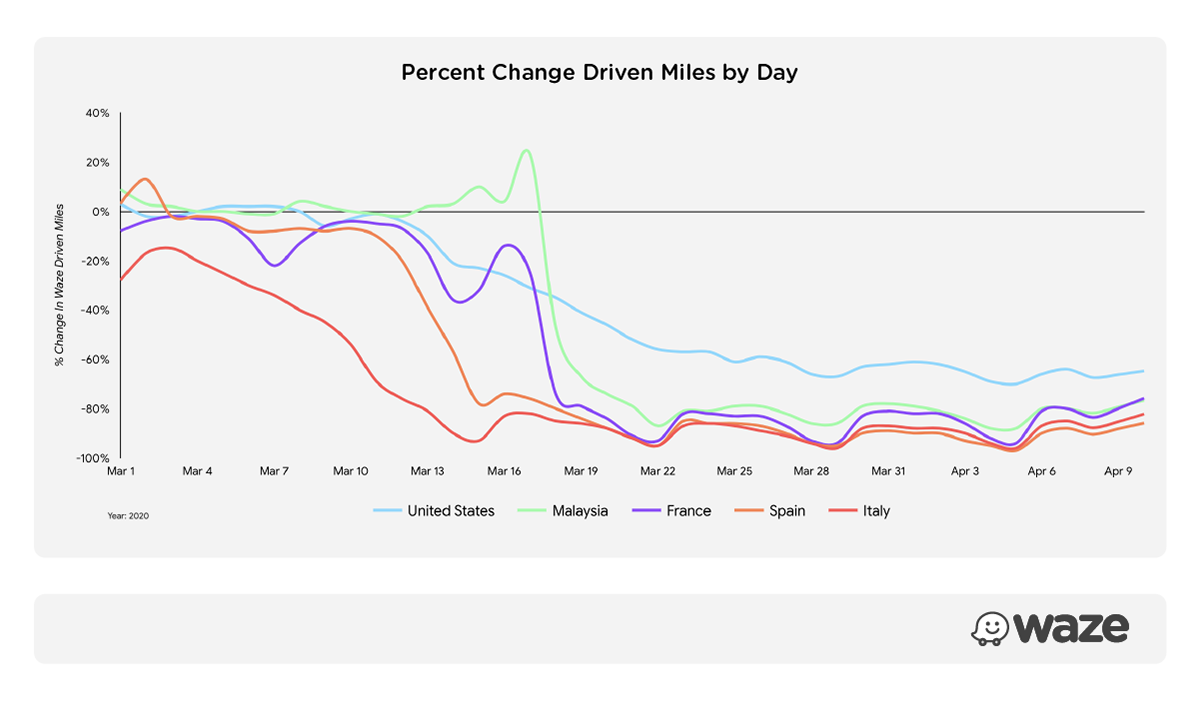
According to Waze, use of their app is down 60% globally since March which is when most of us went under stay at home (or safer at home) orders. In Italy, it’s down 90%!
The reason navigation is down significantly is because not only are people going out less and working remotely, but also new reports show that 300,000 people in North Texas are now jobless due to the coronavirus shutdown. That means demand for emergency food has increased exponentially.

Waze just made it easier to find food assistance by adding more than 30,000 emergency food locations, such as food pantries and food banks, on the app.
This is possible because of partnerships with WhyHunger and NoKidHungry.
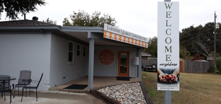
Long lines at food banks and emergency food centers are becoming alarming in the United States, and this week alone at least one school district in North Texas is reported to have run out of food at several locations in Denton due to unexpected high demand after they switched to once weekly food distributions.
The New York-based nonprofit WhyHunger added its “Food Finder” database into Waze and now anyone can track down emergency food locations so they can get food.
One of the benefits of the additional listings to both food banks and people searching for food is that users can be redirected to other area locations to get the food they need.

How To Use Waze To Find Emergency Food Pantry Locations
I tried it out to see just how easy it is to find a food pantry and food bank information on Waze. Here are the steps I took:
Step 1 – Open Waze, perform search
The first thing you will do is open the Waze app and then type into the search field “food pantry” or “food bank.” Perform search.
iPhone: DOWNLOAD WAZE APP STORE
Android: DOWNLOAD WAZE GOOGLE PLAY STORE
Step 2 – Select a nearby food pantry

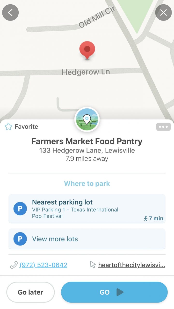
A list of nearby emergency food locations will show up. Scroll through the list to find a nearby food pantry or food bank. Select a nearby food pantry. I was not able to find a special icon for this service in Dallas Fort Worth yet.
Step 3 – Contact the location before you go
THIS IS IMPORTANT! Before heading out, contact the location because most are only open at certain times of the day or week. Sometimes the emergency food center will have a website and you can check that out too.
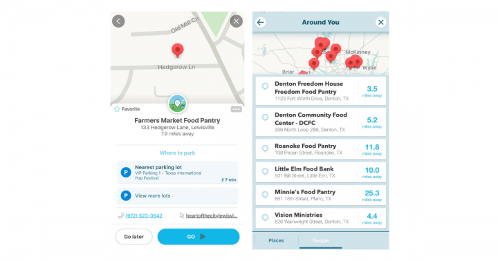
NOTE: I found Waze displays different information depending on if you hit “search” or not and I want you to be aware of it.
WITHOUT tapping “search” on keyboard (iPhone) here is the food pantry list:
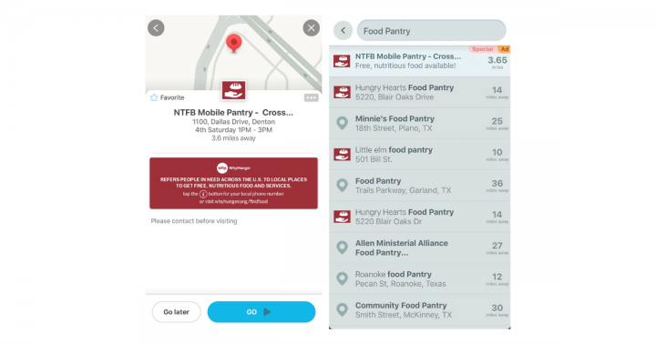
WITH tapping “search” on keyboard (iPhone) here is the food pantry list:
Waze Now Lets You Find 30,000 Emergency Food Pantry Locations Near You
Finding emergency food just got easier for hungry North Texans with Waze’s list of over 30,000 food pantry and food bank locations. Here’s How To Find Emergency Food Near You.

More on Metroplex Social:
- 135 Grocery Store Survival Foods <– Nothing in this list needs refrigeration!!
- How Much Food You’ll Need For The Next 3 Months
- WHEN You’ll Be Getting Your Stimulus Payment
- Apple Has A Brand New iPhone…and it’s actually AFFORDABLE!
- How To Make Baby Wipes
- How To Make Hand Sanitizer
- Home And Gardening Tips
- How To Avoid COVID-19 According To CDC
Have something to say? Leave a comment below.